English
  Italiano
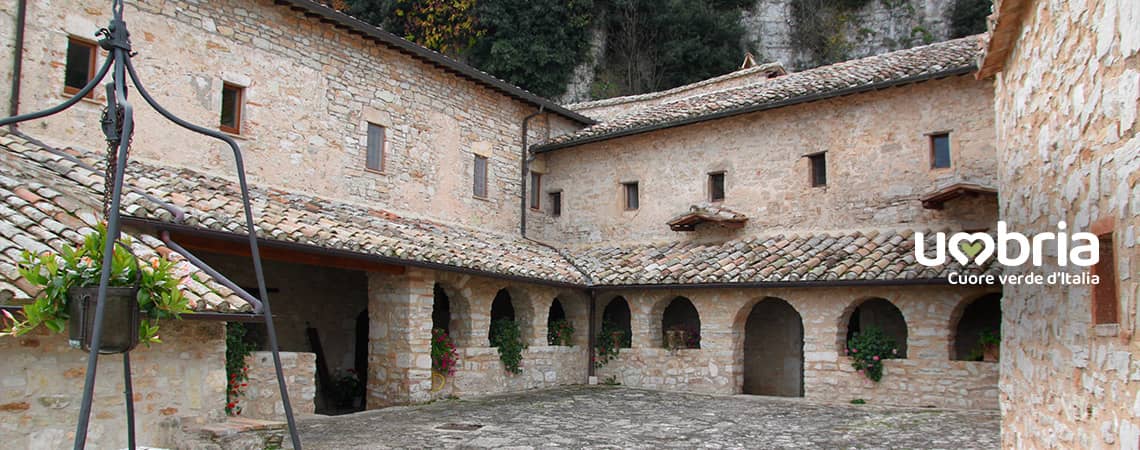
The Way of the Franciscan Proto-martyrs
Stage 2 - from Stroncone to Calvi dell'Umbria
From the Convent of Saint Francis in Stroncone to the Church of Santa Maria Assunta in Calvi dell'Umbria.
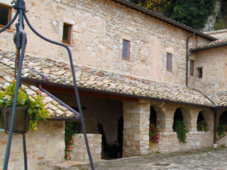
Challenging path due to the ups and downs of the hills and to a high mountain pass towards Calvi dell'Umbria.Pleasant walking through natural surroundings in which to enjoy marvelous landscapes. Just after Aguzzo, the village of St. Accursio, Franciscan protomartyr, the route leads to the Hermitage of St. Urban called the Sacred Hermitage where St. Francis, during his stay, turned water into wine.
For this reason, the poor of Assisi renamed this place the ”Umbrian Cana”. In Calvi dell'Umbria, at the little town of St.
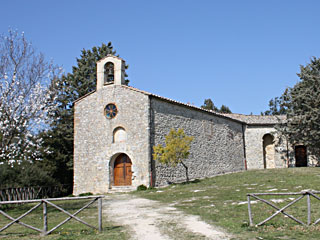
Berardo, our walk comes to an end. Here we can admire a monumental earthenware Nativity of standing figures of the 16th century attributed to Giacomo and Raffaele from Montereale.
The Church of St. Maria Assunta is our arrival point.
From
Stroncone (Convento di San Francesco)
To
Calvi dell'Umbria (Chiesa di Santa Maria Assunta)
Distance
21 Km
Increase in altitude
+ 1.109
Loss of altitude
- 1.096
Surface
dirt road
Road Sign
yes
Travel time
7 hours
Water sources
yes
Resting areas
yes
Degree of difficulty
Challenging
From the parvis, turn right and, at the crossroads, turn right into the provincial road and continue on for 300 metres. Just after you have walked around the bend to the right, walk down the narrow slightly downhill road and, after 400 metres, take a narrow road on the left (at the junction there is a aedicule on which there is the image of the Virgin Mary). Continue on for approximately 1.2 km, cross the crossroads, carrying on straight ahead and go down Strada delle Sore, keeping the Little Church of Santa Maria della Neve on the left.
Continue on downhill along Strada delle Sore without ever leaving the road (do not make any detours, especially the first on the left indicating Forcella and CAI trail to Finocchieto) for about 2 km until you come to the provincial road.Cross over and take the unpaved road (almost opposite) keeping the large tree on your left.
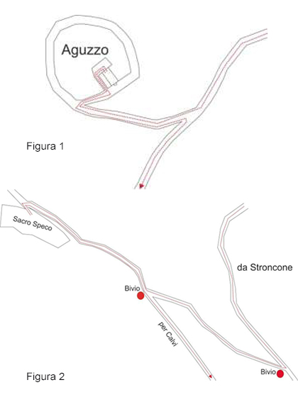 Continue on until you get to the second junction and turn left. Cross the torrent (on the other side of the torrent, you will see the path with a road sign on the left of the path!!!). Walk down this path for 1 km without making any detours. At the crossroads with the tarmac road, turn left and, after 400 metres, take the narrow uphill road on the right. After 100 metres you will have reached Aguzzo (5.5 km from the departure point). See figure 1
Go back along the last stretch in the opposite direction and turn right at the end of the descent. Continue on for 350 metres and then turn right, keeping a little house on your left. After another 300 metres, at the junction, follow the road on the left (there are also other CAI indications) and keep walking straight ahead for 1.5 km. After crossing a small ford, turn left at the crossroads and, after 200 metres, turn right into an uphill road, then continue on for 1 km.
After a bend to the right, walking uphill between the houses, you will come to the tarmac provincial road. Cross it and turn left immediately afterwards (about 20 metres) in front of a house (on the other side of the road you will see a votive aedicule with a statue of Christ Blessing).
Follow the path (signposted by the CAI) for 300 metres until you come to a tarmac road. Cross it and take the unpaved road opposite; after 150 metres, take the steep uphill path to the left (also signposted by the CAI) and continue on for 350 metres. At the crossroads with other paths, turn right (take the uphill path on the right).
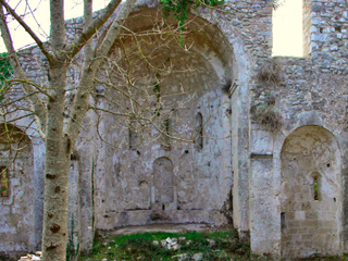
Continue on straight ahead until you reach another crossroads of paths (here there are numerous signposts indicating trails and a notice board of the Condominium of Civic Uses of Vasciano) and continue on straight ahead (it is important that you always walk straight on and take no notice of the other directions), in other words, continue on along the path and, after 600 metres, you will arrive at the Sacro Speco (Holy Cavern) (10.30 km from the departure point). See figure 2
After a visit to the Santo Speco, return to the path that brought you here and continue on in the opposite direction. After about 300 metres, at the junction with the notice board of the Condominium of Civic Uses of Vasciano, take the uphill path on the right. After about 500 metres, where the path comes to a fork, take the uphill one on the right. It is important not to take the path that you encounter 20 metres before the fork and that directs you back towards the Speco nor the one at the junction that directs you downhill to the left.
Continue on for approximately 1 km uphill (a path that is first wide and then narrow, with several hairpin bends after about 500 metres. At the first hairpin bend you will find a wooden bench near the high voltage pylon) until you come to a plateau (at the end of the path you will find a notice board of the Condominium of Civic Uses of Vasciano and a wooden bench).On the plateau, take the unpaved road that you will encounter a few metres further on and turn into this road going left. At the first junction after 200 metres, turn right. Continue on for 400 metres and turn left at the fork, then continue on for 250 metres until you reach a wide bend on the left. On the bend (half way along), take the uphill path on the right (which is in fact opposite) and continue on for 250 metres until you get to the unpaved road. Turn right here and continue on for 750 metres (after a while, the unpaved road becomes a path through some Mediterranean scrub) until you come to a tarmac road.
Turn right into the downhill tarmac road and continue on for 2.3 km until you come to a group of buildings (boarding kennels for dogs) and continue walking downhill always keeping to the right (the kennels must be on your left). Continue on for 3.80 km until you reach a wide crossroads (just before it, you will be walking alongside the cemetery wall on your right).
Turn right at the crossroads and, after 100 metres, turn left into a downhill road. Continue on for 400 metres until you reach a crossroads and turn right, again downhill, and walk for another 250 metres. You have finally arrived at Calvi dell'Umbria. This stage ends at the Church of Santa Maria Assunta.
Continue on downhill along Strada delle Sore without ever leaving the road (do not make any detours, especially the first on the left indicating Forcella and CAI trail to Finocchieto) for about 2 km until you come to the provincial road.Cross over and take the unpaved road (almost opposite) keeping the large tree on your left.
Continue on until you get to the second junction and turn left. Cross the torrent (on the other side of the torrent, you will see the path with a road sign on the left of the path!!!). Walk down this path for 1 km without making any detours. At the crossroads with the tarmac road, turn left and, after 400 metres, take the narrow uphill road on the right. After 100 metres you will have reached Aguzzo (5.5 km from the departure point). See figure 1Go back along the last stretch in the opposite direction and turn right at the end of the descent. Continue on for 350 metres and then turn right, keeping a little house on your left. After another 300 metres, at the junction, follow the road on the left (there are also other CAI indications) and keep walking straight ahead for 1.5 km. After crossing a small ford, turn left at the crossroads and, after 200 metres, turn right into an uphill road, then continue on for 1 km.
After a bend to the right, walking uphill between the houses, you will come to the tarmac provincial road. Cross it and turn left immediately afterwards (about 20 metres) in front of a house (on the other side of the road you will see a votive aedicule with a statue of Christ Blessing).
Follow the path (signposted by the CAI) for 300 metres until you come to a tarmac road. Cross it and take the unpaved road opposite; after 150 metres, take the steep uphill path to the left (also signposted by the CAI) and continue on for 350 metres. At the crossroads with other paths, turn right (take the uphill path on the right).
Continue on straight ahead until you reach another crossroads of paths (here there are numerous signposts indicating trails and a notice board of the Condominium of Civic Uses of Vasciano) and continue on straight ahead (it is important that you always walk straight on and take no notice of the other directions), in other words, continue on along the path and, after 600 metres, you will arrive at the Sacro Speco (Holy Cavern) (10.30 km from the departure point). See figure 2
After a visit to the Santo Speco, return to the path that brought you here and continue on in the opposite direction. After about 300 metres, at the junction with the notice board of the Condominium of Civic Uses of Vasciano, take the uphill path on the right. After about 500 metres, where the path comes to a fork, take the uphill one on the right. It is important not to take the path that you encounter 20 metres before the fork and that directs you back towards the Speco nor the one at the junction that directs you downhill to the left.
Continue on for approximately 1 km uphill (a path that is first wide and then narrow, with several hairpin bends after about 500 metres. At the first hairpin bend you will find a wooden bench near the high voltage pylon) until you come to a plateau (at the end of the path you will find a notice board of the Condominium of Civic Uses of Vasciano and a wooden bench).On the plateau, take the unpaved road that you will encounter a few metres further on and turn into this road going left. At the first junction after 200 metres, turn right. Continue on for 400 metres and turn left at the fork, then continue on for 250 metres until you reach a wide bend on the left. On the bend (half way along), take the uphill path on the right (which is in fact opposite) and continue on for 250 metres until you get to the unpaved road. Turn right here and continue on for 750 metres (after a while, the unpaved road becomes a path through some Mediterranean scrub) until you come to a tarmac road.
Turn right into the downhill tarmac road and continue on for 2.3 km until you come to a group of buildings (boarding kennels for dogs) and continue walking downhill always keeping to the right (the kennels must be on your left). Continue on for 3.80 km until you reach a wide crossroads (just before it, you will be walking alongside the cemetery wall on your right).
Turn right at the crossroads and, after 100 metres, turn left into a downhill road. Continue on for 400 metres until you reach a crossroads and turn right, again downhill, and walk for another 250 metres. You have finally arrived at Calvi dell'Umbria. This stage ends at the Church of Santa Maria Assunta.
What you should know before departure
Sources
There are water fountains in locality Coppe, Aguzzo, Ville di Vasciano (fountain off course of 200 meters ask for directions on site) and Sacro Speco. Remember to fill your water bottle with at least 1.5 litres of water in the summer.
There are water fountains in locality Coppe, Aguzzo, Ville di Vasciano (fountain off course of 200 meters ask for directions on site) and Sacro Speco. Remember to fill your water bottle with at least 1.5 litres of water in the summer.
Intermediate stages
During this stage, there are no places equipped for lunch, so you need to take a packed lunch to be eaten even at the Speco di Narni.(Cavern of Narni)
During this stage, there are no places equipped for lunch, so you need to take a packed lunch to be eaten even at the Speco di Narni.(Cavern of Narni)
Suggestions
For a large part of this stage of the journey you will be walking along mountain paths, so it is important that you remember to take note of the Alpine and Speleological Rescue procedures in Umbria, by taking a look at the website: www.sasu.it
We recommend that you have the maps of the trail with you.
Information (e.g. how to get there using public transport)
Terni Municipal Police Tel. 0744 334935
Calvi Municipal Police Tel. 0744 710119
Terni Municipal Police Tel. 0744 334935
Calvi Municipal Police Tel. 0744 710119
Must-see
The Way of the Franciscan Proto-martyrs