English
  Italiano
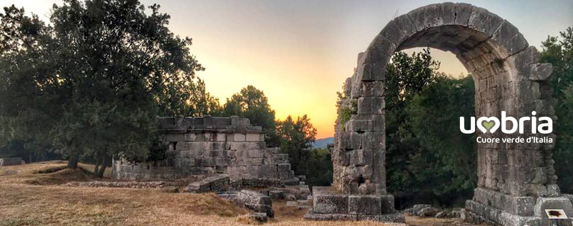
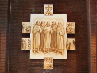
The Way of the Franciscan Proto-martyrs
Stage 5 - from San Gemini to Cesi
A challenging route taking you along mountain paths.
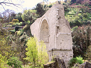
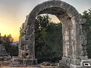
Challenging path due to the difficult ascent to the Hermitage of Portaria, also known as the Romita, in Cesi and subsequent descent towards Cesi.Along the way it is possible to visit the wonderful archaeological site of Carsulae, a very important ancient Roman city.
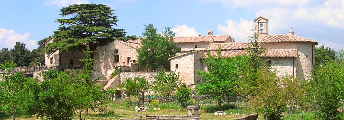
We reach the Romita, an ancient franciscan Hermitage, deep in the lush green of the forest. Saint Francis of Assisi, who used to pray here, had the monastery built in 1213. It is believed that here St. Francis composed the Exhortatio ad laudem Dei, a religious canticle, considered as an early version of Cantico di Frate Sole (Canticle of the Sun). Possibility of accommodation.
The village of Cesi, overlooking the Terni basin, is rich in history.
The Church of Santa Maria Assunta is our arrival point.
From
San Gemini (Chiesa di San Francesco)
To
Cesi (Chiesa di Santa Maria Assunta)
Distance
12 Km
Increase in altitude
+ 654
Loss of altitude
- 540
Surface
dirt road
Road Sign
yes
Travel time
5-6 hours
Water sources
yes
Resting areas
yes
Degree of difficulty
Challenging
With your back to the main door of the Church of Saint Francis, take Via Casentino, going through the arch on the other side of the square and, at the end of the road, you will find a little square, Piazza Garibaldi. From here, walk downhill along Via delle Mura and go through the arch of the medieval gateway.
As soon you have gone through the gateway, walk downhill along Via San Giovanni on the left. At the end of the road turn left at the junction into Via del Sole, walking along the pavement on the left-hand side. At the next junction with the provincial road (Via Tuderte) walk along the bicycle lane on the right and follow it until you reach the San Gemini station.
 At the end of the bicycle lane, be careful as you cross the road. Continue on along Via Tiberina being careful as you cross the railway flyover. Continue on along the provincial road for 800 metres (be careful, as the road is wide but busy) until you reach a large crossroads.
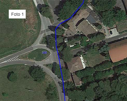
Here, don’t take the road on the left, don’t go straight on and don’t take the first road on the right, but take the second road on the right, called Via Carsuae, after going past the large sign of the Antica Carsulae restaurant. See photo 1
Continue on for approximately 750 metres along Via Carsulae and, after passing a beautiful cottage on your left, walking slightly uphill, you will come to a crossroads with five roads. Take the second road on the left (the one with directions to the Bar and that has an open metal barrier).
It is a slightly uphill unpaved road and, after 200 metres, you will find the barred road with a pedestrian walkway. After going past the little bar on the right and the Carsulae Archaeological Park ticket office, which we strongly advise you to visit, (3.9 km from the departure point), continue on along the dirt road for 400 metres and walk through the underpass.
After going through the underpass and a small building on your right, turn left through the cark park (instead of exiting from the car park), take the path in front of you, between the lampposts, for about 10 metres and when you come to a very wide unpaved road, turn right and continue on uphill along this road for approximately 2.2 km until you get to a signpost (on the right) indicating "La Romita".
Take the path and follow it for about 600 metres until you reach the Romita di Cesi hermitage (7.3 km from the departure point).
After your visit to the Romita di Cesi hermitage, continue walking, from the place you entered, turning right into a narrow road. After 100 metres, turn right onto a path with a little stone wall on the right-hand side. Continue on, keeping to the main path (do not make any detours) for 1.2 km until you reach some ruins that you will first find in front of you and then walk alongside them for a short stretch on the right.
Continue on for 150 metres (after passing a slight bend to the right) and take the path on the left (a yellow TAU makes it recognisable).
Continue on along the path for 100 metres until you reach a clearing.
Take the path that leads uphill through the clearing and then into the woods. Continue on for 500 metres after the clearing, until you come to an unpaved road. Turn right downhill into the unpaved road and, after 30 metres, take the path on the left, just before the slight bend to the right that follows on from the downhill unpaved road (be very careful here). Continue on for 200 metres until you come to another unpaved road running down from the mountains. Important!!! Take the path in front of you, without following the unpaved road either downhill or uphill.
Continue on for 700 metres, without making any detours, always following the path until you reach an old spring.
When you reach the spring, continue on around a bend to the right (do not take the uphill path).
Continue on for another 1000 metres without making any detours until you come to a tarmac road. After crossing the tarmac road, turn right downhill and continue on for 800 metres until you find the entrance to the village of Cesi on the left (the entrance is on a very narrow downhill bend to the right) in Via Angelo Cesi. Continue on for 150 metres in Via Angelo Cesi and, on the right, there are some steps (after going past a small square) that will take you to the parvis of the Church of Santa Maria Assunta.
As soon you have gone through the gateway, walk downhill along Via San Giovanni on the left. At the end of the road turn left at the junction into Via del Sole, walking along the pavement on the left-hand side. At the next junction with the provincial road (Via Tuderte) walk along the bicycle lane on the right and follow it until you reach the San Gemini station.
At the end of the bicycle lane, be careful as you cross the road. Continue on along Via Tiberina being careful as you cross the railway flyover. Continue on along the provincial road for 800 metres (be careful, as the road is wide but busy) until you reach a large crossroads. Here, don’t take the road on the left, don’t go straight on and don’t take the first road on the right, but take the second road on the right, called Via Carsuae, after going past the large sign of the Antica Carsulae restaurant. See photo 1
Continue on for approximately 750 metres along Via Carsulae and, after passing a beautiful cottage on your left, walking slightly uphill, you will come to a crossroads with five roads. Take the second road on the left (the one with directions to the Bar and that has an open metal barrier).
It is a slightly uphill unpaved road and, after 200 metres, you will find the barred road with a pedestrian walkway. After going past the little bar on the right and the Carsulae Archaeological Park ticket office, which we strongly advise you to visit, (3.9 km from the departure point), continue on along the dirt road for 400 metres and walk through the underpass.
After going through the underpass and a small building on your right, turn left through the cark park (instead of exiting from the car park), take the path in front of you, between the lampposts, for about 10 metres and when you come to a very wide unpaved road, turn right and continue on uphill along this road for approximately 2.2 km until you get to a signpost (on the right) indicating "La Romita".
Take the path and follow it for about 600 metres until you reach the Romita di Cesi hermitage (7.3 km from the departure point).
After your visit to the Romita di Cesi hermitage, continue walking, from the place you entered, turning right into a narrow road. After 100 metres, turn right onto a path with a little stone wall on the right-hand side. Continue on, keeping to the main path (do not make any detours) for 1.2 km until you reach some ruins that you will first find in front of you and then walk alongside them for a short stretch on the right.
Continue on for 150 metres (after passing a slight bend to the right) and take the path on the left (a yellow TAU makes it recognisable).
Continue on along the path for 100 metres until you reach a clearing.
Take the path that leads uphill through the clearing and then into the woods. Continue on for 500 metres after the clearing, until you come to an unpaved road. Turn right downhill into the unpaved road and, after 30 metres, take the path on the left, just before the slight bend to the right that follows on from the downhill unpaved road (be very careful here). Continue on for 200 metres until you come to another unpaved road running down from the mountains. Important!!! Take the path in front of you, without following the unpaved road either downhill or uphill.
Continue on for 700 metres, without making any detours, always following the path until you reach an old spring.
When you reach the spring, continue on around a bend to the right (do not take the uphill path).
Continue on for another 1000 metres without making any detours until you come to a tarmac road. After crossing the tarmac road, turn right downhill and continue on for 800 metres until you find the entrance to the village of Cesi on the left (the entrance is on a very narrow downhill bend to the right) in Via Angelo Cesi. Continue on for 150 metres in Via Angelo Cesi and, on the right, there are some steps (after going past a small square) that will take you to the parvis of the Church of Santa Maria Assunta.
What you should know before departure
Sources
There are water fountains in: Bar near the springs of Sangemini - Bar at the entrance to the Carsulae archaeological park - Romita di Cesi (Fra Bernardino).
There are water fountains in: Bar near the springs of Sangemini - Bar at the entrance to the Carsulae archaeological park - Romita di Cesi (Fra Bernardino).
Intermediate stages
During this stage, there are no places equipped for lunch, so you need to take a packed lunch can even be eaten at the Romita di Cesi hermitage, as Friar Bernardino offers excellent hospitality. Bar near the springs of Sangemini - Bar at the entrance to the Carsulae archaeological park.
During this stage, there are no places equipped for lunch, so you need to take a packed lunch can even be eaten at the Romita di Cesi hermitage, as Friar Bernardino offers excellent hospitality. Bar near the springs of Sangemini - Bar at the entrance to the Carsulae archaeological park.
Suggestions
For a large part of this stage of the journey you will be walking along mountain paths, so it is important that you remember to take note of the Alpine and Speleological Rescue procedures in Umbria, by taking a look at the website: www.sasu.it
We recommend that you have the maps of the trail with you.
Information (e.g. how to get there using public transport)
San Gemini Municipal Police Tel. 0744 334935
Terni Municipal Police Tel. 0744 426000
San Gemini Municipal Police Tel. 0744 334935
Terni Municipal Police Tel. 0744 426000
Must-see
Chiesa di Santa Maria Assunta - Cesi
Chiesa di San Damiano - Carsulae
The Way of the Franciscan Proto-martyrs