English
  Italiano
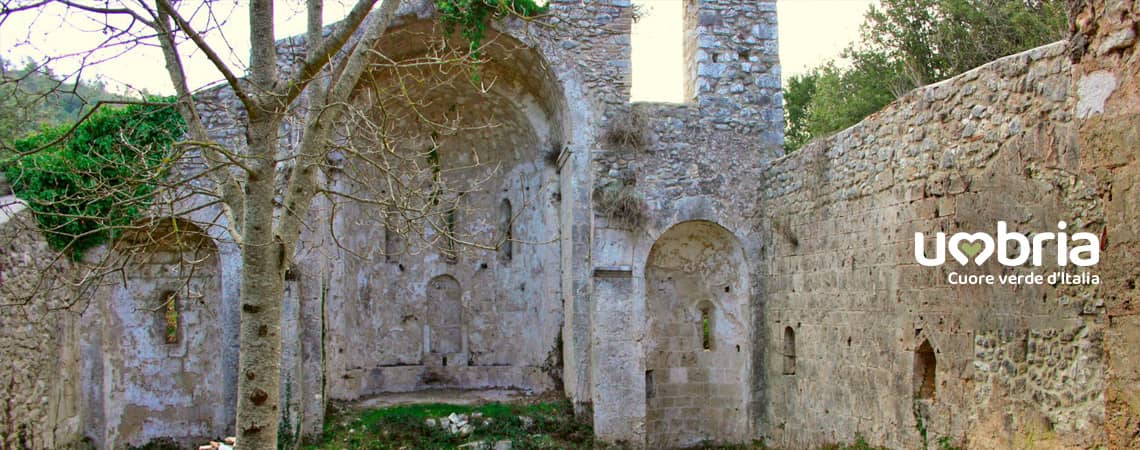
The Way of the Franciscan Proto-martyrs
Stage 1 - from Terni to Stroncone
From the Church of Santa Maria della Pace in Terni to the Convent of Saint Francis in Stroncone.
Walking in the hills of Terni.
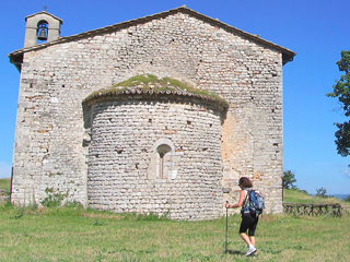
Challenging path due to the ups and downs of the hills surrounding Terni. The pilgrimage takes place surrounded by natural scenery. The Church of Santa Maria della Pace ( St. Mary of Peace) enshrines a cycle of paintings by Stefano di Stasio devoted to the Franciscan Proto-martyrs.
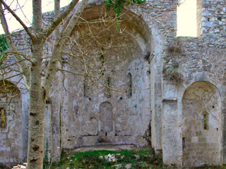
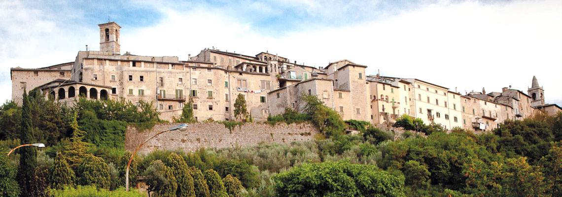
The trail takes us past the evocative ruins of the Benedictine Abbey of San Benedetto (St. Benedict) in Fundis and the Monastery of San Simeone (St. Simeon) occupied today by the religious community of the Ricostruttori nella Preghiera; these sites enrich the landscape and the gorgeous natural beauty of the hills. Stroncone, St.Ottone's birthplace is one of the most charming medieval villages of this area.
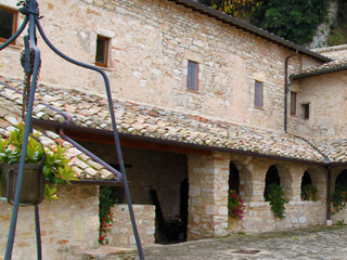
The thirteenth century Convent of San Francesco (St. Francis) is our arrival point.
From
Terni (Chiesa di Santa Maria della Pace)
To
Stroncone (Convento di San Francesco)
Distance
11 Km
Increase in altitude
+ 757
Loss of altitude
- 587
Surface
dirt road
Road Sign
yes
Travel time
4/5 hours
Water sources
yes
Resting areas
yes
Degree of difficulty
Challenging
From the main door (with your back to it) of the Church of Santa Maria della Pace, turn left into Via Ippocrate and continue on for 300 metres. Then turn right into Strada di Perticara, walking over a little bridge.
From the little bridge, continue on for 1200 metres until you reach a junction. Turn left at the junction and after 100 metres, at the next junction, take the unpaved road on the right and continue on for 750 metres along the unpaved road until you reach a junction (crossroads).
 At the crossroads, take the unpaved road on the left, which runs slightly downhill, and continue on for approximately 850 metres until you reach the intersection with a concrete road.
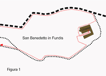
Turn left into the is slightly uphill concrete road, continue on for 1800 metres uphill along an unpaved/concrete road until you reach Saint Benedict's well (fonte di San Benedetto) on the right. Continue on along the road for 200 metres, turn right into an opening in a field with walnut trees and continue on for 30 metres until you see the ruins of the Abbey of San Benedetto in Fundis on the right (5.25 km from the departure point). See figure 1
Take the small road on the left slightly downhill (on the right there is a large plant) and start following the external side of the church for about 30 meters; turn left flanking the apse and, after another 30 meters, turn right passing between the external side of the church and a building on the right.
Here begins the visit of the Abbey missing both the roof and the floor.
After visiting the church, go back about 30 m, take the opening on the left, leaving the apse on the right, and take the path that descends to the right (initially follow the walnut trees).
Continue along the path for about 150 m and, after having made first a bend to the left (be careful not to take the small path on the right, but continue on the main path) and then one to the right, you will meet a fork in the path. Take the path on the left that goes up towards the inside of the forest.
Go on following the main path for 1,30 Km until you cross a wide path. Here pay attention, turn left first and immediately after take on the right a downhill path.
Follow the path for approximately 200 metres until you reach a wide unpaved road with a raised iron barrier on the left.
Turn left and continue on for 50 metres until you reach the entrance to the Monastery of San Simeone (7.00 km from the departure point).
After seeing the monastery, take to the road again and continue on ahead for 550 metres, towards the barrier, until you encounter a small crossroads and take the steep downhill concrete road on the left.
Continue on for 200 metres and, when you reach the big bend on the right, follow the main road, heading right, and the continue on for another 180 metres until you come to a junction.
Take the road on the right, which leads into the residential area, and continue on for 250 metres until you get to a little square.
At the little square, take the downhill lane on the left with a traffic light.
Walk down the lane for 350 metres until you come to a little bridge; after crossing the bridge, the road begins to climb and you will come to a sharp bend to the left. Continue on without taking the secondary lane on the right of the bend. After 400 metres, you will come to a road – turn left into this road (you will see a large car park on the left before the crossroads). After 50 metres, to the right of a widening in the road, turn into an internal road running between the houses and continue on for 150 metres until you come to a municipal road.
At the crossroads, take the first road on the left (not the wide municipal road). This is a steep uphill road. Continue on uphill for 300 metres until you get to a medieval entrance gateway to the village on the left (Porta di Sotto).
After going through the gateway, turn left and then right and right again. Turn into Via Sebastiano Vici until you get to Piazza San Giovanni and go through the main gateway into the little town.In Piazza della Libertà, between the fountain and the bar, take Via San Francesco downhill and continue on, taking the municipal road for 300 metres until you get to the crossroads of municipal roads.Be careful when you cross the road and, after crossing, take the narrow road opposite (florist on the left) and after 50 metres you will arrive at the Convent of Saint Francis
From the little bridge, continue on for 1200 metres until you reach a junction. Turn left at the junction and after 100 metres, at the next junction, take the unpaved road on the right and continue on for 750 metres along the unpaved road until you reach a junction (crossroads).
At the crossroads, take the unpaved road on the left, which runs slightly downhill, and continue on for approximately 850 metres until you reach the intersection with a concrete road. Turn left into the is slightly uphill concrete road, continue on for 1800 metres uphill along an unpaved/concrete road until you reach Saint Benedict's well (fonte di San Benedetto) on the right. Continue on along the road for 200 metres, turn right into an opening in a field with walnut trees and continue on for 30 metres until you see the ruins of the Abbey of San Benedetto in Fundis on the right (5.25 km from the departure point). See figure 1
Take the small road on the left slightly downhill (on the right there is a large plant) and start following the external side of the church for about 30 meters; turn left flanking the apse and, after another 30 meters, turn right passing between the external side of the church and a building on the right.
Here begins the visit of the Abbey missing both the roof and the floor.
After visiting the church, go back about 30 m, take the opening on the left, leaving the apse on the right, and take the path that descends to the right (initially follow the walnut trees).
Continue along the path for about 150 m and, after having made first a bend to the left (be careful not to take the small path on the right, but continue on the main path) and then one to the right, you will meet a fork in the path. Take the path on the left that goes up towards the inside of the forest.
Go on following the main path for 1,30 Km until you cross a wide path. Here pay attention, turn left first and immediately after take on the right a downhill path.
Follow the path for approximately 200 metres until you reach a wide unpaved road with a raised iron barrier on the left.
Turn left and continue on for 50 metres until you reach the entrance to the Monastery of San Simeone (7.00 km from the departure point).
After seeing the monastery, take to the road again and continue on ahead for 550 metres, towards the barrier, until you encounter a small crossroads and take the steep downhill concrete road on the left.
Continue on for 200 metres and, when you reach the big bend on the right, follow the main road, heading right, and the continue on for another 180 metres until you come to a junction.
Take the road on the right, which leads into the residential area, and continue on for 250 metres until you get to a little square.
At the little square, take the downhill lane on the left with a traffic light.
Walk down the lane for 350 metres until you come to a little bridge; after crossing the bridge, the road begins to climb and you will come to a sharp bend to the left. Continue on without taking the secondary lane on the right of the bend. After 400 metres, you will come to a road – turn left into this road (you will see a large car park on the left before the crossroads). After 50 metres, to the right of a widening in the road, turn into an internal road running between the houses and continue on for 150 metres until you come to a municipal road.
At the crossroads, take the first road on the left (not the wide municipal road). This is a steep uphill road. Continue on uphill for 300 metres until you get to a medieval entrance gateway to the village on the left (Porta di Sotto).
After going through the gateway, turn left and then right and right again. Turn into Via Sebastiano Vici until you get to Piazza San Giovanni and go through the main gateway into the little town.In Piazza della Libertà, between the fountain and the bar, take Via San Francesco downhill and continue on, taking the municipal road for 300 metres until you get to the crossroads of municipal roads.Be careful when you cross the road and, after crossing, take the narrow road opposite (florist on the left) and after 50 metres you will arrive at the Convent of Saint Francis
What you should know before departure
Sources
There are water fountains in Monastero di San Simeone; In several months of the year there is also water at the Well of Saint Benedict near San Benedetto in Fundis. Remember to fill your water bottle with at least 1.5 litres of water in the summer.
There are water fountains in Monastero di San Simeone; In several months of the year there is also water at the Well of Saint Benedict near San Benedetto in Fundis. Remember to fill your water bottle with at least 1.5 litres of water in the summer.
Intermediate stages
During this stage, there are no places equipped for lunch, so you need to take a packed lunch with you.
Shop/Groceries available in the locality of Colle.
During this stage, there are no places equipped for lunch, so you need to take a packed lunch with you.
Shop/Groceries available in the locality of Colle.
Suggestions
For a large part of this stage of the journey you will be walking along mountain paths, so it is important that you remember to take note of the Alpine and Speleological Rescue procedures in Umbria, by taking a look at the website: www.sasu.it
We recommend that you have the maps of the trail with you.
Information (e.g. how to get there using public transport)
Terni Municipal Police Tel. 0744 426000
Stroncone Municipal Police Tel. 0744 334935
To get to the Church of Santa Maria della Pace, take the no. 8 bus (Monday - Saturday) Terni FS(railway station)-Urbinati-Larviano.
Take a look at the bus timetables: www.fsbusitalia.it
Terni Municipal Police Tel. 0744 426000
Stroncone Municipal Police Tel. 0744 334935
To get to the Church of Santa Maria della Pace, take the no. 8 bus (Monday - Saturday) Terni FS(railway station)-Urbinati-Larviano.
Take a look at the bus timetables: www.fsbusitalia.it
Must-see
The Way of the Franciscan Proto-martyrs