English
  Italiano
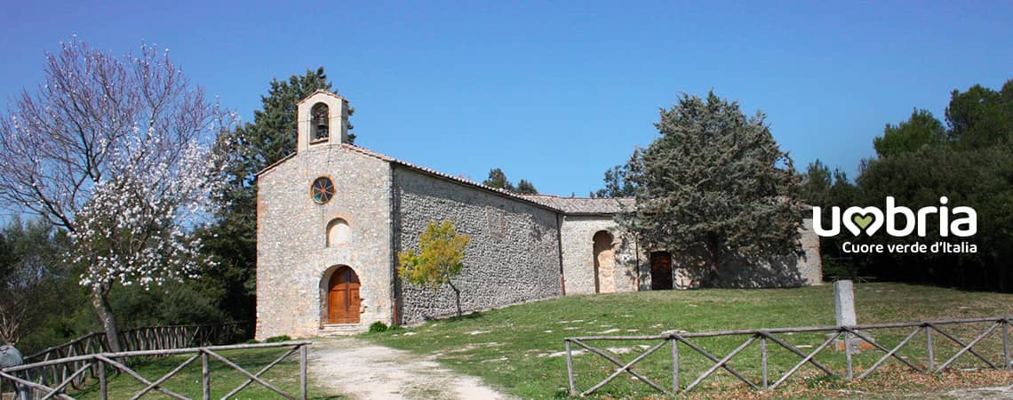
The Way of the Franciscan Proto-martyrs
Stage 3 - from Calvi dell'Umbria to Narni
This stage is the one with the most places to visit of the entire walk.
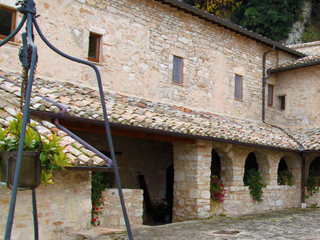
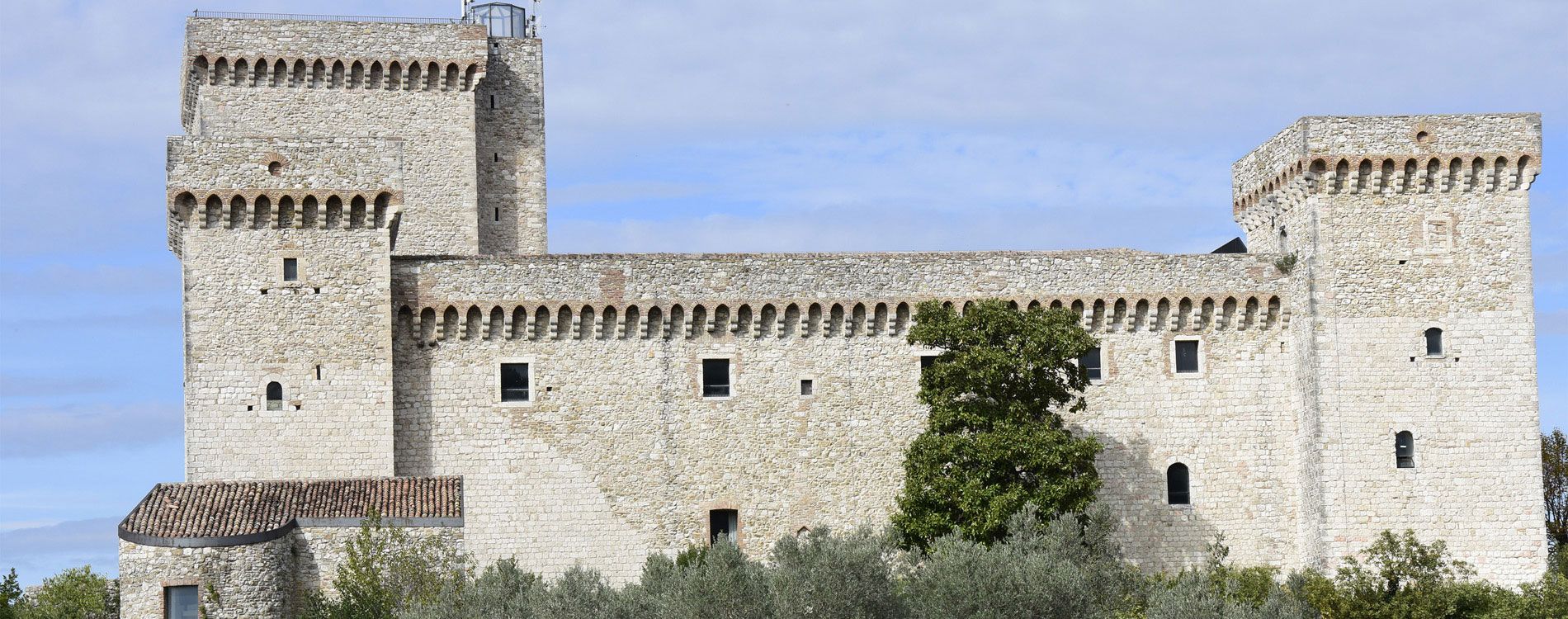
This is definitely the richest path of highly spiritual places of faith of our pilgrimage. It starts with the Church of St. Michele Arcangelo (Michael Arcangel), an old Benedictine Abbey in Schifanoia and continues with the ancient Roman Church of St. Pudenziana and the church of St. Angelo in Massa, originally a Benedictine abbey, and finishes with the impressive Albornoz Fortress in Narni, the land of St. Adiuto.
Narni is a marvelous medieval town with stunning treasures, famous for the magnificent cathedral and for the “ Race to the Ring”, a festival dedicated to the Patron Saint Giovenale (St. Juvenal).
The thirteenth century Church of St. Francis is our arrival point.
From
Calvi dell'Umbria (Chiesa di Santa Maria Assunta)
To
Narni (Chiesa di San Francesco)
Distance
28,28 Km
Increase in altitude
+ 693
Loss of altitude
- 852
Surface
tarmac
Road Sign
yes
Travel time
10 hours
Water sources
yes
Resting areas
yes
Degree of difficulty
Medium
With your back to the main door of the Church, turn left and go through the arch of the entrance gateway to the village. Continue on along a downhill road for 200 metres and, at the crossroads, take the downhill road situated opposite (Via Santa Lucia). Continue on for 200 metres and, at the next crossroads, cross the main road. Continue along on the right for 150 metres and turn left, taking the provincial road in the direction of Otricoli. After 200 metres, you will find the Church of Saint Francis on the right, (what a pity that it's closed). Continue on along the Calvi SP 71 Provincial Road for 1 km and then turn right, following the road signs for San Silvestro. Continue on for 1 km and then turn right and walk downhill for 1 km, always following this road. Then turn left at the crossroads and, after 50 metres, turn right (basically, just follow the main road) and continue on until you reach the little village of Poggiolo.
At the Church, which is on the left, walk alongside the bell-tower and turn into the first lane that leads into the group of buildings. Follow the narrow road and turn left at the first crossroads. Take the downhill path to the right and continue on for 1 km, following the unpaved road without making any detours.At the crossroads with the tarmac road, turn left (you will see a little church on the right) and continue on for 300 metres. At the bend of the provincial road, go straight on in the direction of Santa Maria and, after 250 metres, at the first widening of the road take the narrow downhill road on the left. Carry on for 1.5 km, following the unpaved road without making any detours. At the crossroads turn right uphill along a narrow tarmac road, Strada di Santo Janni, and continue on for 1 km. Then, at the crossroads (with Strada di Montini) go straight ahead in Strada di Collespino and walk along it for about 900 metres until you reach a downhill road, Strada Santa Maria della Petrella. Turn left (almost like making a sharp turn) and continue on downhill for 300 metres. Then turn right into an unpaved road bordered by fences both on the right and on the left and continue on for 1.3 km.Turn left at the junction (like following a slight bend to the left) into Strada di Moricone and continue on for 300 metres. At the little square, Piazzetta di Schifanoia, turn right taking an uphill road and continue on for 300 metres. Then turn left into an unpaved road, following the directions for San Michele Arcangelo and after 100 metres you will arrive at the Church of San Michele Arcangelo (11.80 km from the departure point).
Set off from the Church again, taking the unpaved road on the left for 250 metres. At the crossroads, turn left and continue on for a further 250 metres and turn left again. Then, at the next junction, turn left following directions for Vigne.
Continue on for 550 metres until you reach a junction. Turn into the lane on the left (opposite the yellow house on your right) and continue on for 150 metres. At the junction, take the road on the right (in fact you are walking straight on) and continue on for 250 metres to the next junction. Turn right into a downhill road and continue on another 70 metres until you come to the municipal road. Turn left and continue through the village of Vigne for 450 metres, then turn right as soon as you have gone past a white house on your right. Turn into a steep downhill unpaved road (above you, you will see the viaduct of the provincial road). Just after the viaduct, after 50 metres, turn left and just after the little ditch, turn right and continue on along the path/tractor road downhill for 200 metres, then turn right and go past the little ditch again. Continue on until you have passed along a passage between two tall walls of earth - as if it were a gap through the hill.
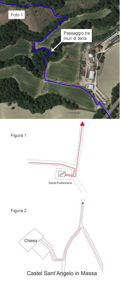 Be careful here (See photo 1) and follow the road for another 50 metres. Turn right, walking alongside the field, passing by the thicket (which you will keep on your left) as if you were going back and until you encounter a narrow passageway on the left that goes into the little thicket.
Continue on along the path until you cross a little torrent. As soon as you have crossed it, turn left for 50 metres and then turn right, following the row of little trees for about 100 metres. Inside a little thicket you will reach an unpaved road/tractor path and turn left. Continue on along the unpaved road/path for tractors for about 450 metres (first follow the bend to the right, almost a hairpin bend, and then follow a steep uphill tractor path through a field) until you come to a tarmac road. Turn left and continue on for 1.8 km along the road that becomes unpaved further on, until you reach a junction where you must go straight on and, after another 400 metres, turn right at the next junction (take the uphill road).
Here, on the left, 20 metres after the junction, a narrow downhill road will take you to a well 50 metres further on.
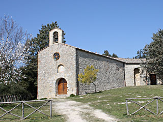
Continue on along the slightly uphill unpaved road for 900 metres until you reach a junction. Be careful here. First turn right and walk for about 30 metres and the Church of Santa Pudenziana will appear on the right (18.30 km from the departure point). See figure 1
From Santa Pudenziana, with the main door of the church behind you, turn left and go back to the previous junction. Continue on along the tarmac road for about 900 metres until you get to a crossroads. Take the unpaved road on the right and continue on for 200 metres. The Church of San Martino in Taizzano will appear on the left (19.50 km from the departure point).
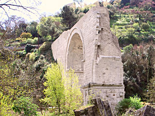
After visiting the church, continue on along the same road for 300 metres, without making any detours, and turn right at the junction. Continue on for another 400 metres until you come to the 3TER/Via Tiberina provincial road and be careful when crossing it. Walk to the unpaved road opposite and continue on along it for 150 metres until you get to a junction. Take the unpaved road on the left and continue on for 250 metres until you reach a clearing. Be careful not to take the road that turns left, but continue on along the path/unpaved road in front and continue on for 650 metres. At the fork, turn left and continue on for 200 metres. Turn left at the crossroads you come to. Be careful here. First continue on for 100 metres and, on the right, you will find the entrance to the complex of Sant'Angelo in Massa (21.00 km from the departure point). See figure 2
After visiting the complex, go back along the last stretch of road (100 metres) in the opposite direction and turn left at the crossroads (in other words walk alongside the metal fence, keeping it on your left) and continue on along the unpaved road for 3 km (the last stretch is tarmac road) until you get to a junction. Make a sharp right turn into the slightly uphill tarmac road and, after 15 metres, take the pedestrian walkway on the left, which leads to an underpass of the provincial road.
After going through the underpass, turn left immediately and go into a car park. From the car park, continue on for 100 metres and turn right (you will see the Church of Testaccio on the left). Continue on for 50 metres and then take the slightly uphill unpaved road on the left and continue on for 200 metres. On the left, you will find an uphill path (there is a high iron gate on the right). Take the path and continue on for 300 metres until you reach a clearing (meadow) and be careful to continue on across the clearing (the path may not be visible) for 150 metres, until you have crossed it completely.
On the other side, take the unpaved road and continue on for 350 metres, first on level ground and then uphill, until you come to a wide unpaved road. Turn left and walk straight ahead, following the road for 800 metres until you come to a tarmac road. Turn right and continue on for 200 metres until you reach the Albornoz Fortress (26.10 km from the departure point).
After visiting the fortress, walk back for 50 metres and then along the pedestrian walkway on the left. Then walk around the Fortress, turning onto a secondary lane, and continue on for 400 metres until you find some small public gardens on the right. Continue on for another 100 metres (Via Feronia) and turn right into Via Aspromonte.
Walk all the way along Via Aspromonte and continue on downhill until you reach Via XX Settembre. Continue on until you get to Piazza Garibaldi.After going past the fountain in the square, keeping it on your right, walk towards the arch (with the traffic light) on the right and, just after it, on the left you will see the Cathedral of Narni. After visiting the Cathedral, continue on along Via Giuseppe Garibaldi, turn left immediately into Via del Campanile and walk all the way along this road until you reach the Church of Saint Francis on the left.
At the Church, which is on the left, walk alongside the bell-tower and turn into the first lane that leads into the group of buildings. Follow the narrow road and turn left at the first crossroads. Take the downhill path to the right and continue on for 1 km, following the unpaved road without making any detours.At the crossroads with the tarmac road, turn left (you will see a little church on the right) and continue on for 300 metres. At the bend of the provincial road, go straight on in the direction of Santa Maria and, after 250 metres, at the first widening of the road take the narrow downhill road on the left. Carry on for 1.5 km, following the unpaved road without making any detours. At the crossroads turn right uphill along a narrow tarmac road, Strada di Santo Janni, and continue on for 1 km. Then, at the crossroads (with Strada di Montini) go straight ahead in Strada di Collespino and walk along it for about 900 metres until you reach a downhill road, Strada Santa Maria della Petrella. Turn left (almost like making a sharp turn) and continue on downhill for 300 metres. Then turn right into an unpaved road bordered by fences both on the right and on the left and continue on for 1.3 km.Turn left at the junction (like following a slight bend to the left) into Strada di Moricone and continue on for 300 metres. At the little square, Piazzetta di Schifanoia, turn right taking an uphill road and continue on for 300 metres. Then turn left into an unpaved road, following the directions for San Michele Arcangelo and after 100 metres you will arrive at the Church of San Michele Arcangelo (11.80 km from the departure point).
Set off from the Church again, taking the unpaved road on the left for 250 metres. At the crossroads, turn left and continue on for a further 250 metres and turn left again. Then, at the next junction, turn left following directions for Vigne.
Continue on for 550 metres until you reach a junction. Turn into the lane on the left (opposite the yellow house on your right) and continue on for 150 metres. At the junction, take the road on the right (in fact you are walking straight on) and continue on for 250 metres to the next junction. Turn right into a downhill road and continue on another 70 metres until you come to the municipal road. Turn left and continue through the village of Vigne for 450 metres, then turn right as soon as you have gone past a white house on your right. Turn into a steep downhill unpaved road (above you, you will see the viaduct of the provincial road). Just after the viaduct, after 50 metres, turn left and just after the little ditch, turn right and continue on along the path/tractor road downhill for 200 metres, then turn right and go past the little ditch again. Continue on until you have passed along a passage between two tall walls of earth - as if it were a gap through the hill.
Be careful here (See photo 1) and follow the road for another 50 metres. Turn right, walking alongside the field, passing by the thicket (which you will keep on your left) as if you were going back and until you encounter a narrow passageway on the left that goes into the little thicket. Continue on along the path until you cross a little torrent. As soon as you have crossed it, turn left for 50 metres and then turn right, following the row of little trees for about 100 metres. Inside a little thicket you will reach an unpaved road/tractor path and turn left. Continue on along the unpaved road/path for tractors for about 450 metres (first follow the bend to the right, almost a hairpin bend, and then follow a steep uphill tractor path through a field) until you come to a tarmac road. Turn left and continue on for 1.8 km along the road that becomes unpaved further on, until you reach a junction where you must go straight on and, after another 400 metres, turn right at the next junction (take the uphill road).
Here, on the left, 20 metres after the junction, a narrow downhill road will take you to a well 50 metres further on.
Continue on along the slightly uphill unpaved road for 900 metres until you reach a junction. Be careful here. First turn right and walk for about 30 metres and the Church of Santa Pudenziana will appear on the right (18.30 km from the departure point). See figure 1
From Santa Pudenziana, with the main door of the church behind you, turn left and go back to the previous junction. Continue on along the tarmac road for about 900 metres until you get to a crossroads. Take the unpaved road on the right and continue on for 200 metres. The Church of San Martino in Taizzano will appear on the left (19.50 km from the departure point).
After visiting the church, continue on along the same road for 300 metres, without making any detours, and turn right at the junction. Continue on for another 400 metres until you come to the 3TER/Via Tiberina provincial road and be careful when crossing it. Walk to the unpaved road opposite and continue on along it for 150 metres until you get to a junction. Take the unpaved road on the left and continue on for 250 metres until you reach a clearing. Be careful not to take the road that turns left, but continue on along the path/unpaved road in front and continue on for 650 metres. At the fork, turn left and continue on for 200 metres. Turn left at the crossroads you come to. Be careful here. First continue on for 100 metres and, on the right, you will find the entrance to the complex of Sant'Angelo in Massa (21.00 km from the departure point). See figure 2
After visiting the complex, go back along the last stretch of road (100 metres) in the opposite direction and turn left at the crossroads (in other words walk alongside the metal fence, keeping it on your left) and continue on along the unpaved road for 3 km (the last stretch is tarmac road) until you get to a junction. Make a sharp right turn into the slightly uphill tarmac road and, after 15 metres, take the pedestrian walkway on the left, which leads to an underpass of the provincial road.
After going through the underpass, turn left immediately and go into a car park. From the car park, continue on for 100 metres and turn right (you will see the Church of Testaccio on the left). Continue on for 50 metres and then take the slightly uphill unpaved road on the left and continue on for 200 metres. On the left, you will find an uphill path (there is a high iron gate on the right). Take the path and continue on for 300 metres until you reach a clearing (meadow) and be careful to continue on across the clearing (the path may not be visible) for 150 metres, until you have crossed it completely.
On the other side, take the unpaved road and continue on for 350 metres, first on level ground and then uphill, until you come to a wide unpaved road. Turn left and walk straight ahead, following the road for 800 metres until you come to a tarmac road. Turn right and continue on for 200 metres until you reach the Albornoz Fortress (26.10 km from the departure point).
After visiting the fortress, walk back for 50 metres and then along the pedestrian walkway on the left. Then walk around the Fortress, turning onto a secondary lane, and continue on for 400 metres until you find some small public gardens on the right. Continue on for another 100 metres (Via Feronia) and turn right into Via Aspromonte.
Walk all the way along Via Aspromonte and continue on downhill until you reach Via XX Settembre. Continue on until you get to Piazza Garibaldi.After going past the fountain in the square, keeping it on your right, walk towards the arch (with the traffic light) on the right and, just after it, on the left you will see the Cathedral of Narni. After visiting the Cathedral, continue on along Via Giuseppe Garibaldi, turn left immediately into Via del Campanile and walk all the way along this road until you reach the Church of Saint Francis on the left.
What you should know before departure
Sources
There are water fountains in Poggiolo, Villa Santa Maria, Schifanoia, Chiesa San Michele Arcangelo, Vigne, Chiesa di Santa Pudenziana (on the right of the church) and Testaccio. Remember to fill your water bottle with at least 1.5 litres of water in the summer.
There are water fountains in Poggiolo, Villa Santa Maria, Schifanoia, Chiesa San Michele Arcangelo, Vigne, Chiesa di Santa Pudenziana (on the right of the church) and Testaccio. Remember to fill your water bottle with at least 1.5 litres of water in the summer.
Intermediate stages
There are places equipped for lunch during this stage.
There are places equipped for lunch during this stage.
Suggestions
We recommend that you have the maps of the trail with you.
We recommend that you have the maps of the trail with you.
Information (e.g. how to get there using public transport)
Calvi Municipal Police Tel. 0744 710119
Narni Municipal Police Tel. 0744 747260
Calvi Municipal Police Tel. 0744 710119
Narni Municipal Police Tel. 0744 747260
Must-see
Chiesa di San Martino - Taizzano
The Way of the Franciscan Proto-martyrs